Forum Announcement, Click Here to Read More From EA_Cade.
Custom Height Maps become nearly flat when importing
 M13Vulpecula
Posts: 19,720 Member
M13Vulpecula
Posts: 19,720 Member
I've got this annoying issue when importing custom-made Height Maps into the tool as a base for my world. When I import this map...
[img]https://🐸🐸🐸🐸.googleusercontent.com/-U1C5t29Cvzg/VHdHgnRrzkI/AAAAAAAABbQ/eHuOYjuV6ZQ/s256-no/dddd.png[/img]
... The map just ends up being way too flat then it should be, and it also ends up way above the water level.
[img]https://🐸🐸🐸🐸.googleusercontent.com/-MHmt4AWC7eI/VHdIhsOFDXI/AAAAAAAABbs/dx7t0kVv3kY/w1026-h577-no/Close%2BShot.jpg[/img]
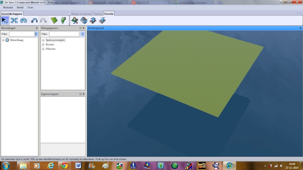
The world I'm trying to make is a 154x154 square island in the middle on a world map of 256x256. My idea island sticks out of the water about 2,5 to 3 in-game floors.
It's really annoying me, since I need a perfect square to start with, opting out editing in the tool, and this is way too flat for me to use for my world idea. If I use other maps, it just works fine. Does anybody have any idea what went wrong and how to solve this issue? I'd be eternally grateful.
[img]https://🐸🐸🐸🐸.googleusercontent.com/-U1C5t29Cvzg/VHdHgnRrzkI/AAAAAAAABbQ/eHuOYjuV6ZQ/s256-no/dddd.png[/img]
... The map just ends up being way too flat then it should be, and it also ends up way above the water level.
[img]https://🐸🐸🐸🐸.googleusercontent.com/-MHmt4AWC7eI/VHdIhsOFDXI/AAAAAAAABbs/dx7t0kVv3kY/w1026-h577-no/Close%2BShot.jpg[/img]
The world I'm trying to make is a 154x154 square island in the middle on a world map of 256x256. My idea island sticks out of the water about 2,5 to 3 in-game floors.
It's really annoying me, since I need a perfect square to start with, opting out editing in the tool, and this is way too flat for me to use for my world idea. If I use other maps, it just works fine. Does anybody have any idea what went wrong and how to solve this issue? I'd be eternally grateful.

0
Comments
How annoying.
You can use the Mask tool to make it perfectly square...
Get the height you want- 300 if you want dive lots- then raise the land in the center to where you can raise the water level to 30 (add layer/place object at waterline to check in property box).
Then you can use the Mask Tool- set square at 100- for around the edges of the map (at its lowest level) and into where you want the land to start- This way you can raise the land to where you want it and raise the water level if you want dive lots.
I hope I explained it well enough.
This is using mask to make a square hole.
Thank you for your advice, I think I can work it out with it. Now I'm eternally grateful
Good Luck!
But now, I've got a new issue. At the border of the map, some hideous land is peeking out of the water. It actually IS the border of the map. :c
I've got no single idea how to get rid of it. Can you please help me?
Turn on the Grid (Top of Toolbar) so you can see the land levels underwater.