Forum Announcement, Click Here to Read More From EA_Cade.
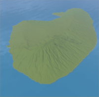
ラナイ島のインポート Import Island of Lanai ( Import Real-maps Project )
 OWell
Posts: 44
OWell
Posts: 44
Japanese:
この画像は、NASAの ”Shuttle Radar Topography Mission (SRTM)”の標高データを使用して います。
そのデータを”カシミール3D”で読み込み、 ”L3DT”で加工してハイトマップ を作成しました。
それを、『CAWT - Beta』にインポートしました。
English:
This image is using the altitude data of NASA "Shuttle Radar Topography Mission (SRTM)".
The data was made to read into "kashmir 3D", it was processed by "L3DT", and the height map was created. It was imported to "CAWT - Beta".
* This text translated Japanese into English with helped of translation machines.
+ Import Real-maps Project: http://www.4shared.com/dir/Mjp2SgOQ/import_Real-maps_Project.html
+ 関連
Relation: http://forum.thesims3.com/jforum/posts/list/199167.page
+ 手順書(日本語のみ OpenOffice.org Calc)
procedure manual (Japanese only, OpenOffice.org Calc & need IPA Font):
http://www.4shared.com/file/Tjlf7IPQ/_online.html
0
Comments
This looks great for generating map. The terrain looks wonderful without having to do a lot of sculpting.
I'm going to give it a try soon.
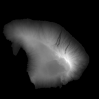
A display sets up the height map in "Kashmir 3D" as follows.
* This text translated Japanese into English with helped of translation machines.
Click.